Answer to Question 1
ANSWER: The weather along the stationary front in Fig. 11.15 is clear to partly cloudy, with much colder air lying on its eastern side. Because both air masses (the cP and the mP) along the front are relatively dry, there is no precipitation. This is not, however, always the case. When warm moist air rides up and over the cold air, widespread cloudiness with light precipitation can cover a vast area. In some cases where a stationary front butts up against a mountain range winds blowing upslope can generate light rain or snow (upslope precipitation) if there is enough moisture in the air.
Answer to Question 2
ANSWER: Heading toward a warm front, the following weather sequence is commonly observed. At first, cirrus (Ci) clouds gradually thicken into a thin, white veil of cirrostratus (Cs) whose ice crystals cast a halo around the Sun. Almost imperceptibly, the clouds thicken and lower, becoming altocumulus (Ac) and altostratus (As) through which the Sun shows only as a faint spot against an overcast gray sky. Snowflakes begin to fall, and we are still over 600 km (370 mi) from the surface front. The snow increases, and the clouds thicken into a sheet-like covering of nimbostratus (Ns). The winds become brisk out of the southeast, while the atmospheric pressure slowly falls. Within 400 km (250 mi) of the front, the cold surface air mass is now quite shallow. The surface air temperature moderates and, as we approach the front, the light snow changes first into sleet. It then becomes freezing rain and finally rain and drizzle as the air temperature climbs above freezing. Overall, precipitation remains light or moderate but covers a broad area. Moving still closer to the front, warm, moist air mixes with cold, moist air, producing ragged wind-blown stratus (St) and fog.

 In old age, as in all other stages of the life course, people find life more pleasant if they have ...
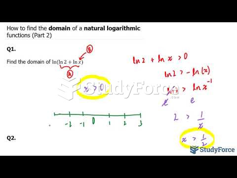 How to find the domain of a natural logarithmic functions (Part 2)
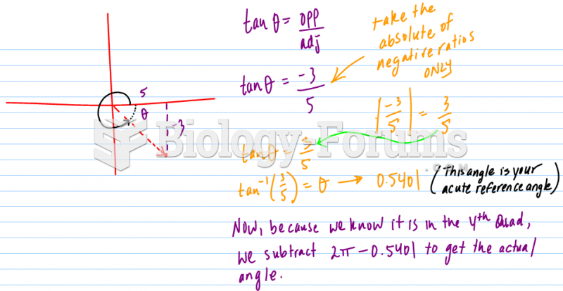 Find angles (in radians) from trigonometric ratio
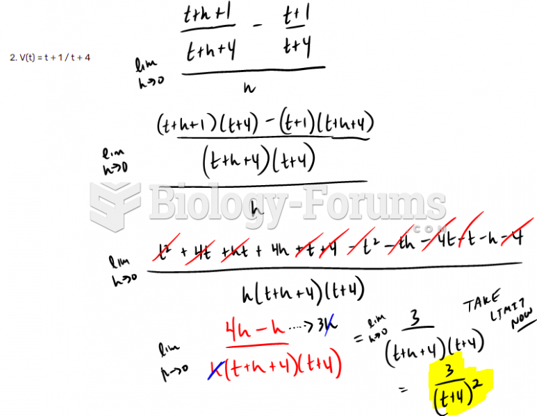 Find derivative by using definition of the derivative question 2
 Find the derivative by using the chain rule - Solution Help
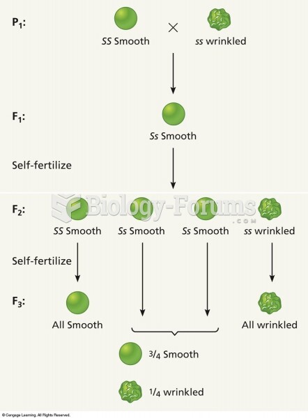 Self-crossing F2 plants to produce an F3 generation shows that there are two different genotypes amo