Answer to Question 1
by opinion and argument. Nuanced answer might argue for being allowed in a legal sense but discouraged because of the risk of migration on the open seas.
Answer to Question 2
Answer: A bajada is formed when numerous alluvial fans grow and coalesce. Therefore, the west side of Death Valley must have seen more advanced growth of its alluvial fans than the east side. Why is this? A couple of reasons suggest themselves: It may be that there is simply more sediment being supplied on the west side. This effect, in turn, could be due to a couple different reasons. The drainage basin supplying those western fans/bajada may be larger, or it may have to do with the Panamint Mountains being taller (note the snow) than the Amargosa Range. Or perhaps the drainage basins are the same size, but the Panamints are being weathered more rapidly than the Amargosas. Or perhaps the reason has nothing to do with sediment supply, but with the tectonics of the Basin and Range. If the faults bounding Death Valley are operating at different rates, that could explain the asymmetry to the sedimentary landforms flanking it. For instance, if the western basin-bounding fault was active in the past, but shows no modern movement, then sediment could pile up atop its trace. Meanwhile, if the fault between the Amargosa Range and eastern Death Valley is really active, then perhaps the eastern side is dropping down much faster, like a trap door, and any alluvial fans are getting buried beneath playa deposits. Evidence supporting this interpretation includes (a) the fact that the playa lake at Badwater is noticeably deeper in the east, and (b) the fault scarp that is cutting across the alluvial fan in the inset photograph.

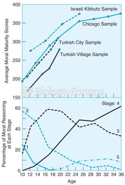 The upper panel shows that scores of four diverse samples of boys on a moral reasoning test show a ...
 Answer to Chem Question
 Answer to Vector Question Pt. 1
 Answer
 ODDS AND PROBABILITY PLEASE ANSWER ALL I DONT HAVE ENOUGH CREDITS
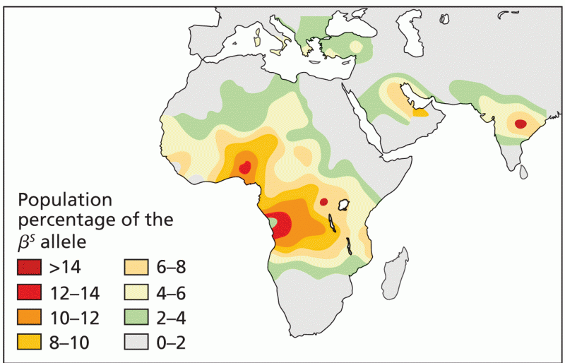 The frequency distribution of the allele in Africa, Southern Europe, the Middle East