Answer to Question 1
ANSWER: There are several methods we can use in forecasting the movement of surface pressure systems and fronts. The following are a few of these forecasting rules of thumb:
1. For short-time intervals, mid-latitude cyclonic storms and fronts tend to move in the same direction and at approximately the same speed as they did during the previous six hours (providing, of course, there is no evidence to indicate otherwise).
2. Low-pressure areas tend to move in a direction that parallels the isobars in the warm air (the warm air sector) ahead of the cold front.
3. Lows tend to move toward the region of greatest pressure drop, while highs tend to move toward the region of greatest rise.
4. Surface pressure systems tend to move in the same direction as the wind at 5500 m (18,000 ft)the 500-mb level. The speed at which surface systems move is about half the speed of the winds at this level.
Answer to Question 2
ANSWER: A United Nations agencythe World Meteorological Organization (WMO), which includes more than 175 nationsis responsible for the international exchange of weather data and certifies that the observation procedures do not vary among nations. This is an extremely important task, since the observations must be comparable. Weather information from all over the world is transmitted electronically to government meteorological centers worldwide. This includes the National Centers for Environmental Prediction (NCEP), a branch of the National Weather Service (NWS) located at the University of Maryland in College Park, just outside Washington, D.C. Here, the massive job of analyzing the data, running models, preparing weather maps and charts, and predicting the weather on a global and national basis begins. From NCEP, observations and computer model output are transmitted to U.S. private forecasting firms and public agencies. Many of NCEPs products are also posted on the web. Across the nation, dozens of NWS Weather Forecast Offices (WFOs) use the information to issue local and regional weather forecasts. Standard forecasts are prepared every 12 hours and updated as needed in between these intervals. Private companies produce forecasts for the public, sent through media outlets and the Internet, as well as tailored forecasts for clients in transportation, recreation, and other areas of special interest.

 Herniated intervertebral disk: the herniated nucleus pulposus is applying pressure
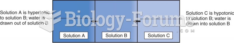 Effects of Differences in Solute Concentration on the Movement of Water Molecules
 These monolithic figures from Easter Island suggest the contemplative nature of philosophy, which ca
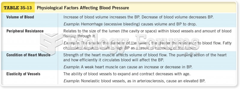 Physiological Factors Affecting Blood Pressure
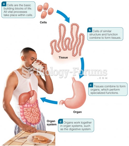 From Cells to Organs and Organ Systems
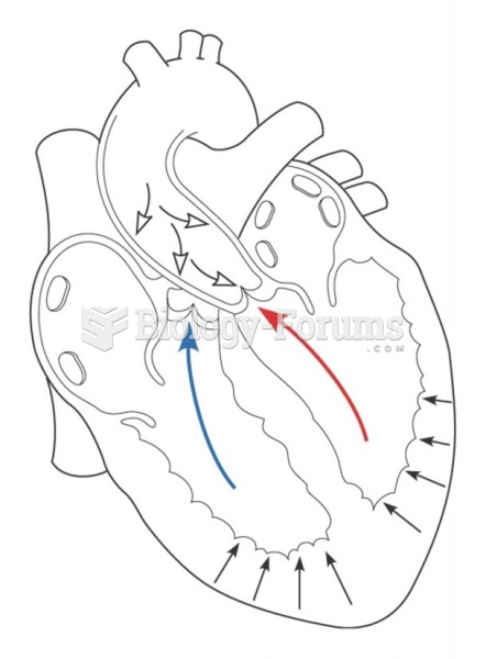 Afterload is the pressure that the ventricles must overcome in order to open the aortic and pulmonic