Answer to Question 1
This section of Chapter 1 introduces the structure of the text and gives the students a preview of how the course will be structured. Chapters 2, 3, and 4 are thematic and cover specific aspects of the geography of North America. This introduction to thematic and regional geography also creates the opportunity to introduce your students to how the discipline of geography is structured and the ways that individual geographers specialize. At this point it might be useful to introduce students to the work of individual geographers, either those in your own department/program or the work of the authors of this text.
A discussion of regions and regionalization can quite logically lead into a discussion of types of regions. Geographers generally discuss two types of regions, formal and functional. Understanding the differences between formal and functional regions can be confusing. A functional region is a region defined by functional linkages such as a transportation network in which a core is connected to outlying areas. A formal region is defined, on the other hand, by a shared characteristic. The most obvious example of a functional region is a metropolitan area that is functionally linked in a number of ways; for example, transportation and economic networks. But a city is also an example of a formal region, defined by a shared governmental structure. Understanding the difference between formal and functional regions will be useful throughout the course since the way that the text divides North America into regional chapters is based on both shared characteristics and functional linkages within each region. A useful way to approach the formal versus functional distinction is to think of these as two different characteristics of regions. For example, North America is a region defined both by functional linkages and a shared colonial history, which has resulted in certain shared cultural characteristics.
Although the text does not cover the concept, another useful way to introduce regions and regionalization is through vernacular regions. This can easily be facilitated through a small-group exercise in which students are asked to divide a familiar area, such as their home state, into regions. These vernacular regions can be based upon functional linkages, physical characteristics, cultural characteristics, or some mixture of these. Divide the class into groups of three to four students. Give each student a blank map of the state and ask each group to come up with their own regions. Encourage groups to come up with names for their regions and be ready to share their thinking with the rest of the class. It usually takes groups 1015 minutes to come up with their regions. Then some or all of the groups can share their regions with the class. If you have an overhead projector in your classroom, the easiest way to do this is to give the groups blank maps copied on clear overhead sheets and allow them to draw their regions with markers on them. Then each map can be projected for the entire class to see. Many classrooms are now equipped with a document camera, which would allow students to draw their maps on any bank sheet of paper.
This is also a good time to introduce students to resources available to them in the text and on the companion website. Words highlighted in bold throughout the text are defined in the glossary at the back of the book. The companion website includes practice quizzes for each chapter, RSS feeds related to the geography of North America, and web links related to each chapter.
Answer to Question 2
The most obvious way to answer this question is to refer to the geography curriculum standard that states people create regions to interpret Earth's complexity. One way to organize human activities is to divide the Earth into the regions. This book studies one global region, North America. However, it also approaches this region through dividing that region into 13 separate subregions (Figure 1.7). So, a key geographic concept to discuss is scale, and how the scale at which we study something impacts how we view the object of study. In the study of North America, we can make broad generalizations about North America in contrast to other regions of the world such as South America or Europe, but we can also understand that such generalizations may hold true to a greater or lesser extent within different subregions of North America. The text gives the example of California and discusses the variety of places within the state and then within Los Angeles. Your class might have a similar discussion of the regions and places within your state and then, at a smaller scale, within your city. Understanding regions and scales is a very useful way to approach discussions of stereotypes, as stereotypes are in fact generalizations that may hold within them some truth, but also fail to capture the diversity within. So your discussion of regions and subregions could include some discussion of stereotypes of people in those regions.

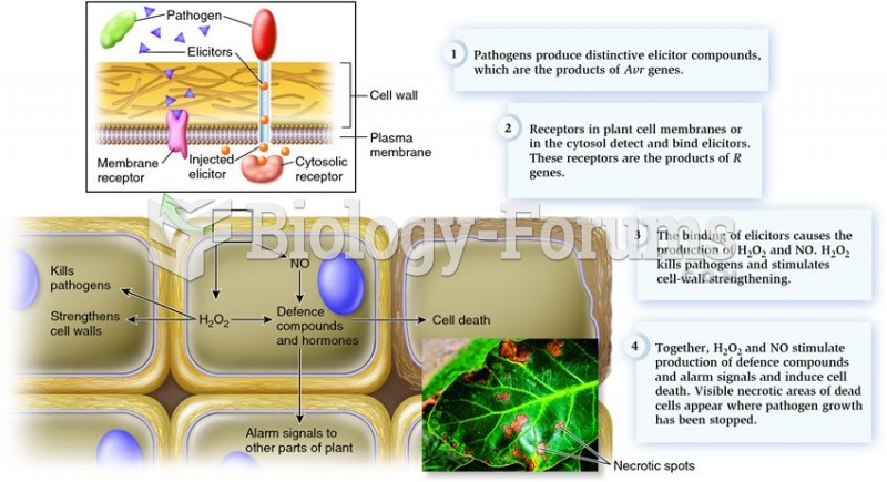 Pathogen/plant interactions and the hypersensitive response to pathogen attack.
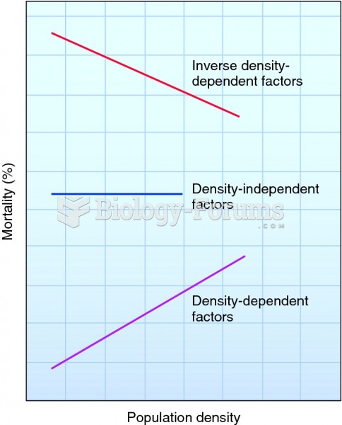 Three ways that factors affect mortality in response to changes in population density.
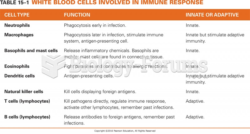 White Blood Cells Involved in Immune Response
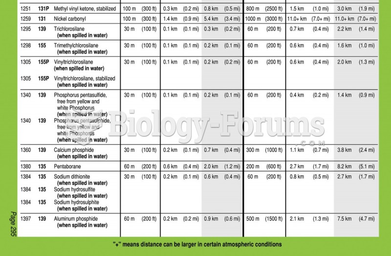 The yellow, blue, and green sections of the Emergency Response Guidebook (ERG). The yellow section ...
 My Shamrock Counting Book 2023
 Kindergarten school year book