Answer to Question 1
ANSWER: Cirrus - Cirrus clouds are thin, wispy clouds blown by high winds into long streamers called mares' tails.
They can look like a white, feathery patch with a faint wisp of a tail at one end.
Cirrocumulus - Cirrocumulus clouds are less common than cirrus clouds and appear as small, rounded, white puffs that may occur individually or in long rows. When in rows, the cirrocumulus cloud has a rippling appearance that distinguishes it from the silky look of cirrus and sheetlike cirrostratus. Cirrocumulus clouds seldom cover more than a small portion of the sky. The dappled cloud elements that reflect the red or yellow light of a setting Sun make this one of the most beautiful of all clouds. The small ripples in the cirrocumulus strongly resemble the scales of a fish; hence, the expression mackerel sky commonly describes a sky full of cirrocumulus clouds.
Cirrostratus - Cirrostratus clouds are thin, sheetlike, high clouds that often cover the entire sky. They are so thin that the Sun and Moon can clearly be seen through them. The ice crystals in these clouds bend the light passing through them and will often produce a haloa ring of light that encircles the Sun or Moon. In fact, the veil of cirrostratus may be so thin that a halo is the only clue to its presence. Thick cirrostratus clouds give the sky a glary white appearance.
Altocumulus - Altocumulus clouds are middle clouds that are composed mostly of water droplets and are rarely more than 1 km (about 3,300 ft) thick. They appear as gray, puffy masses, sometimes rolled out in parallel waves or bands. Usually, one part of each cloud element is darker than another, which helps to separate it from the higher cirrocumulus. Also, individual puffs of the altocumulus appear larger than those of the cirrocumulus. Altocumulus clouds that look like little castles (castellanus) in the sky indicate the presence of rising air at cloud level.
Altostratus - Altostratus clouds are gray or blue-gray clouds composed of ice crystals and water droplets. Altostratus clouds often cover the entire sky across an area that extends over many hundreds of square kilometers. In the thinner section of the cloud, the Sun (or Moon) may be dimly visible as a round disk, as if the Sun were shining through ground glass. This appearance is sometimes referred to as a watery sun.
Nimbostratus - Nimbostratus clouds are dark-gray, wet-looking cloud layers associated with more or less continuously falling rain or snow. The intensity of this precipitation is usually light or moderateit is never of the heavy, showery variety unless well-developed cumulus clouds are embedded within the nimbostratus cloud. Precipitation often makes the base of the nimbostratus cloud impossible to identify clearly. The distance from the cloud's base to its top may be over 3 km (10,000 ft). Nimbostratus is easily confused with altostratus. Thin nimbostratus is usually darker gray than thick altostratus, and you normally cannot see the Sun or Moon through a layer of nimbostratus. Visibility below a nimbostratus cloud deck is usually quite poor because rain will evaporate and mix with the air in this region. If this air becomes saturated a lower layer of clouds or fog may form beneath the original cloud base. Since these lower clouds drift rapidly with the wind, they form irregular shreds with a ragged appearance that are called stratus fractus, or scud.
Stratocumulus - Stratocumulus clouds are low, lumpy clouds that appear in rows, in patches, or as rounded masses with blue sky visible between individual cloud elements. Often they appear near sunset as the spreading remains of a much larger cumulus cloud. Occasionally, the Sun will shine through the cloud breaks producing bands of light (called crepuscular rays) that appear to reach down to the ground. The color of stratocumulus ranges from light to dark gray. It differs from altocumulus in that it has a lower base and larger individual cloud elements. To distinguish between the two, hold your hand at arm's length and point toward one of these clouds. Altocumulus cloud elements will generally be about the size of your thumbnail, whereas stratocumulus will usually be about the size of your fist.
Stratus - Stratus clouds are uniform grayish clouds that often cover the entire sky. They resemble fog that does not reach the ground. Actually, when a thick fog lifts the resulting cloud is a deck of low stratus. Normally, no precipitation falls from stratus clouds, but sometimes it is accompanied by a light mist or drizzle. This cloud commonly occurs over Pacific and Atlantic coastal waters in summer. A thick layer of stratus clouds might be confused with nimbostratus, but the distinction between them can be made by observing the low base of the stratus cloud and remembering that light-to-moderate precipitation occurs with nimbostratus. Moreover, stratus clouds often have a more uniform base than do nimbostratus clouds. Also, a deck of stratus clouds may be confused with a layer of altostratus clouds. However, if you remember that stratus clouds are lower and darker gray and that the Sun normally appears watery through altostratus clouds, the distinction can be made.
Cumulus - Cumulus clouds take on a variety of shapes but most often they look like pieces of floating cotton with sharp outlines and flat bases. The base appears white to light gray, and, on a humid day, may be only 1000 m (3300 ft) above the ground and a kilometer or so wide. The top of the cloudoften in the form of rounded towersdenotes the limit of rising air and is usually not very high. Cumulus clouds are detached (usually with a great deal of blue sky between each cloud), and have dome- or tower-shaped tops. Cumulus clouds that show only slight vertical growth are called cumulus humilis and are associated with fair weather; therefore, we call these clouds fair-weather cumulus. Ragged-edge cumulus clouds that are smaller than cumulus humilis and scattered across the sky are called cumulus fractus. When growing cumulus resembles a head of cauliflower, it becomes a cumulus congestus or towering cumulus. Most often, it is a single large cloud, but, occasionally, several grow into each other, forming a line of towering clouds.
Cumulunimbus - If a cumulus congestus continues to grow vertically, it develops into a giant cumulonimbusa thunderstorm cloud. While its dark base may be no more than 600 m (2000 ft) above Earth's surface, its top may extend upward to the tropopause, over 12,000 m (39,000 ft) higher. A cumulonimbus can occur as an isolated cloud or as part of a line or wall of clouds. Swift winds at the top part of the cloud can reshape the top of the cloud into a huge flattened anvil (cumulonimbus incus). These great thunderheads may contain all forms of precipitationlarge raindrops, snowflakes, snow pellets, and sometimes hailstonesall of which can fall to Earth in the form of heavy showers. Lightning, thunder, and even tornadoes are associated with cumulonimbus clouds. Cumulus congestus and cumulonimbus frequently look alike, making it difficult to distinguish between them. However, you can usually distinguish them by looking at the top of the cloud. If the sprouting upper part of the cloud is sharply defined and not fibrous, it is usually a cumulus congestus; conversely, if the top of the cloud loses its sharpness and becomes fibrous in texture, it is usually a cumulonimbus.
Answer to Question 2
ANSWER: The different main fog types are radiation fog, advection fog, upslope fog, and evaporation (mixing) fog.
Fog produced by Earth's radiational cooling is called radiation fog, or ground fog. It forms best on clear nights when a shallow layer of moist air near the ground is overlain by drier air. Since the moist layer is shallow, it does not absorb much of Earth's outgoing infrared radiation. The ground, therefore, cools rapidly as does the air directly above it, forming a surface inversion with cooler air at the surface and warmer air above. The moist lower layer (chilled rapidly by the cold ground) quickly becomes saturated, and fog forms.
Advection fog forms when warm moist air moves over a cold surface and cools surface air to its saturation point. The surface must be sufficiently cooler than the air above so the transfer of heat from air to surface will cool the air to its dew point and produce fog. Advection fogs also prevail where two ocean currents with different temperatures flow next to one another. Such is the case in the Atlantic Ocean off the coast of Newfoundland, where the cold southward-flowing Labrador Current lies almost parallel to the warm northward-flowing Gulf Stream. Warm southerly air moving over the cold water produces fog in this region so frequently that fog occurs on about two out of three days during summer. Advection fog also forms over land. In winter, warm moist air from the Gulf of Mexico moves northward over progressively colder and slightly elevated land. As the air cools to its saturation point, a fog forms in the southern or central United States.
Because cold ground is often the result of radiational cooling, fog that forms in this manner is sometimes referred to as advection-radiation fog.
Fog that forms as moist air flows up along an elevated plain, hill, or mountain is called upslope fog. Typically, upslope fog forms during the winter and spring on the eastern side of the Rockies, where the eastward-sloping plains are nearly a kilometer higher than the land farther east. Occasionally, cold air moves from the lower eastern plains westward. The air gradually rises, expands, becomes cooler, andif sufficiently moista fog forms. Upslope fogs that form over an extensive area may last for days.
Evaporation (mixing) fog forms when moist, warm air meets cold air and mixes with it. The air becomes saturated and fog forms.

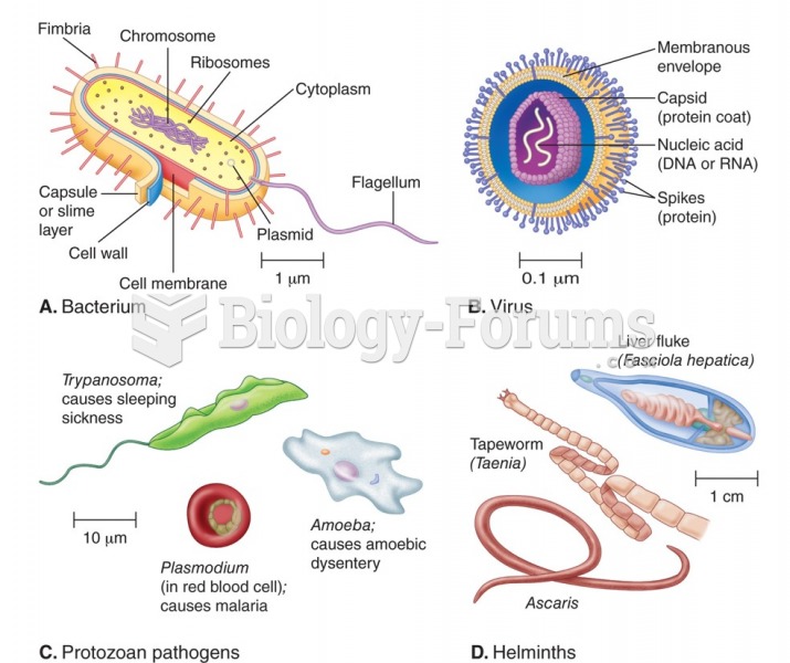 Types of pathogenic organisms: (a) bacterium, (b) virus, (c) protozoan pathogens, (d) multicellular ...
 Various types of integumentary conditions. (G) Burn, second degree.
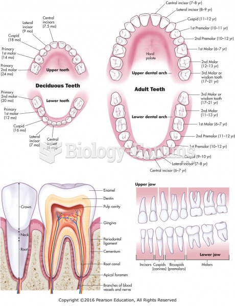 Types, location, and structures of teeth.
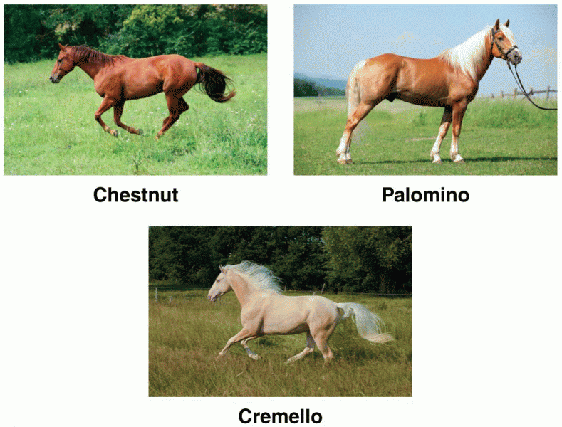 Horses Types
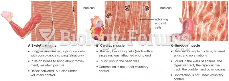 Three types of muscle tissue
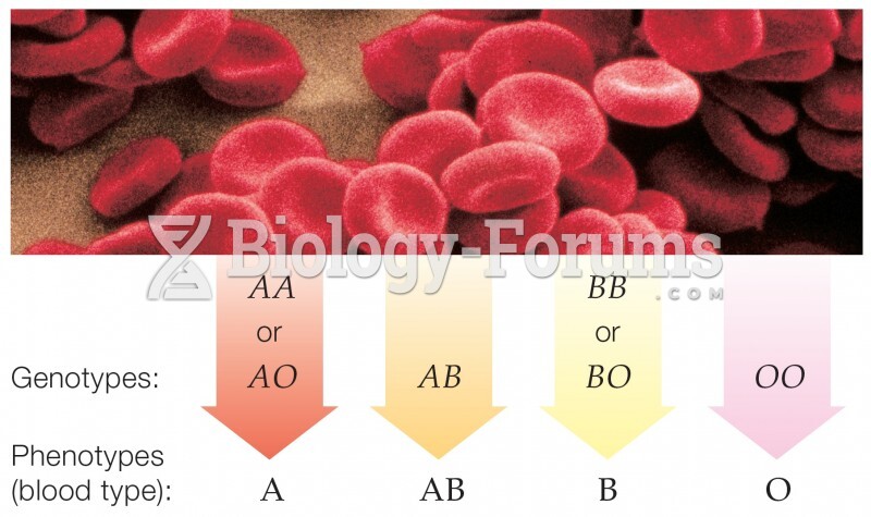 Codominance in ABO Blood Types