Answer to Question 1Satellites have been used to collect oceanographic data since 1978. Satellites beam radar
signals off the sea surface to determine wave height, variations in sea-surface contour and
temperature, and other information of interest to scientists. The first of a new generation of
oceanographic satellites was launched in 1992, TOPEX/Poseidon, as the project is known, is
a satellite orbiting 1,336 kilometers (835 miles) above Earth in an orbit that allows coverage
of 95 of the ice-free ocean every 10 days. The satellite uses a positioning device that allows
researchers to determine its position to within 1 centimeter (12 inch) of Earths center. The
radars aboard can then determine the height of the sea surface with unprecedented accuracy.
Other experiments in this 5-year program include sensing water vapor over the ocean,
determining the precise location of ocean currents, and determining wind speed and direction.
Jason-1, launched in 2001, monitors global climate interactions between the sea and the
atmosphere. AQUA collects data about Earth's water cycle, including evaporation from the
oceans, water vapor in the atmosphere, phytoplankton and dissolved organic matter in the
oceans, and temperature.
Answer to Question 2In the United States, the three pre-eminent oceanographic institutions are the Woods
Hole Oceanographic Institution on Cape Cod, founded in 1930 (and associated with
the Massachusetts Institute of Technology and the neighboring Marine Biological
Laboratory, founded in 1888); the Scripps Institution of Oceanography, founded in
La Jolla, California, and affiliated with the University of California in 1912, and the
LamontDoherty Earth Observatory of Columbia University, founded in 1949.

 The patient and his family meet with the nurse to discuss progress on the patient care plan.
 Cultures Ideal Body Types
 What are examples of ideal forms?
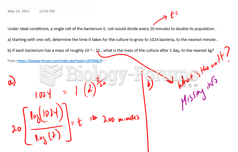 Under ideal conditions, a single cell of the bacterium E. coli would divide every 20 minutes to ...
 Discuss the trend you notice about enbridge inc
 For the circuit in Figure 1, assume ideal diodes. The peak inverse voltage is approximately