Answer to Question 1
ANSWER: Dry haze: forms when the relative humidity of the air is below the point where water vapor begins to condense on active hygroscopic nuclei. The floating particles remain smallusually no larger than about one-tenth of a micrometer. Wet haze: when the relative humidity reaches about 75 percent condensation may begin on the most active hygroscopic nuclei. As water collects on the nuclei, their size increases and haze particles, although still small, become large. Fog: as the relative humidity gradually approaches 100 percent haze particles grow larger and condensation begins on less-active nuclei.
Answer to Question 2
ANSWER: Cirrocumulus clouds appear as small, rounded, white puffs that may occur individually or in long rows. When in rows, the cirrocumulus cloud has a rippling appearance that distinguishes it from the silky look of cirrus and sheetlike cirrostratus. Cirrocumulus seldom cover more than a small portion of the sky. The dappled cloud elements that reflect the red or yellow light of a setting Sun make this one of the most beautiful of all clouds. The small ripples in the cirrocumulus strongly resemble the scales of a fish; hence, the expression mackerel sky commonly describes a sky full of cirrocumulus clouds.
Altocumulus clouds are middle clouds that are composed mostly of water droplets and are rarely more than 1 km (about 3300 ft) thick. They appear as gray, puffy masses, sometimes rolled out in parallel waves or bands. Usually, one part of each cloud element is darker than another, which helps to separate it from the higher cirrocumulus. Also, the individual puffs of the altocumulus appear larger than those of the cirrocumulus.
Cumulus clouds take on a variety of shapes, but they most often look like pieces of floating cotton with sharp outlines and flat bases. The base appears white to light gray, and, on a humid day, may be only 1000 m (3300 ft) above the ground and a kilometer or so wide. The top of the cloudoften in the form of rounded towersdenotes the limit of rising air and is usually not very high. These clouds can be distinguished from stratocumulus by the fact that cumulus clouds are detached (usually with a great deal of blue sky between each cloud), while stratocumulus usually occur in groups or patches. Also, cumulus clouds have a dome- or tower-shaped top as opposed to the general flat tops of stratocumulus clouds.

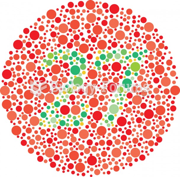 An example of color blindness test. A person with red-green color blindness would not be able to dis
 Cultures Ideal Body Types
 The Number of Children Americans Think Are Ideal
 What are examples of ideal forms?
 Notice the reddish-brown haze caused by nitrogen oxides that is often over many major cities.
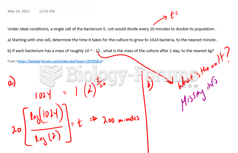 Under ideal conditions, a single cell of the bacterium E. coli would divide every 20 minutes to ...