Answer to Question 1
ANSWER: Answers may vary. There are a number of reasons for discrepancies in weather forecasts and actual weather. For one, computer models have inherent flaws that limit the accuracy of weather forecasts. For example, computer-forecast models idealize the real atmosphere, meaning that each model makes certain assumptions about the atmosphere. These assumptions may be on target for some weather situations and be way off for others. Consequently, the computer may produce a prog that comes quite close to describing the actual state of the atmosphere on one day and not so close on another. Another forecasting problem arises because the majority of models are not global in their coverage, and errors are able to creep in along the models boundaries. For example, a model that predicts the weather for North America may not accurately treat weather systems that move in along its boundary from the western Pacific. Obviously, a global model would usually be preferred. But a global model of similar sophistication with a high resolution requires an incredible number of computations. Even though many thousands of weather observations are taken worldwide each day, there are still regions where observations are sparse, particularly over the oceans and at higher latitudes. To help alleviate this problem, newer satellites are providing a more accurate profile of temperature and humidity for the computer models. Wind information now comes from a variety of sources, such as Doppler radar, commercial aircraft, buoys, and satellites that translate ocean surface roughness into surface wind speed. Grid points used in numerical modeling are each spaced from 100 km to as low as 0.5 km apart. As a consequence, on computer models with large spacing between grid points (say 60 km), larger weather systems, such as extensive mid-latitude cyclones and anticyclones, show up on computer progs, whereas much smaller systems, such as thunderstorms, do not. Because such models are too coarse to generate showers and thunderstorms directly, these features are instead parameterized, meaning that they are approximated for broad areas instead of being predicted by the model for specific points. The computer models that forecast for a large area such as North America are, therefore, better at predicting the widespread precipitation associated with a large cyclonic storm than local showers and thunderstorms. In summer, when much of the precipitation falls as local showers, a computer prog may have indicated fair weather, while outside it is pouring rain. To capture smaller-scale weather features as well as the terrain of the region, the distance between grid points on some models is being reduced. For example, the new High-Resolution Rapid Refresh model has a grid spacing of 3 km, and some experimental models have spacing as low as 0.5 km. Another forecasting problem is that many computer models cannot adequately interpret many of the factors that influence surface weather, such as the interactions of water, ice, surface friction, and local terrain on weather systems. Many large-scale models now take mountain regions and oceans into account. Some models (such as the MM5) take even smaller factors into accountfeatures that large-scale computers miss due to their longer grid spacing. Given the effect of local terrain, as well as the impact of some of the other problems previously mentioned, computer models that forecast the weather over a vast area do an inadequate job of predicting local weather conditions, such as surface temperatures, winds, and precipitation. Even with better observing techniques and near-perfect computer models, there are countless small, unpredictable atmospheric fluctuations called chaos, that limit model accuracy. For example, tiny eddies are much smaller than the grid spacing on the computer model and, therefore, go unaccounted for in the model. These small disturbances, as well as small errors (uncertainties) in the data, generally amplify with time as the computer tries to project the weather farther and farther into the future. After a number of days, these initial imperfections tend to dominate, and the forecast shows little or no accuracy in predicting the behavior of the real atmosphere. In essence, what happens is that the small uncertainty in the initial atmospheric conditions eventually leads to a huge uncertainty in the models forecast. This saturation produces a limit as to how far into the future we will ever be able to accurately forecast the weather at a specific place and time. However, it is still possible to make climatological projections that give the likehood of particular types of weather far into the future.
Answer to Question 2
ANSWER: Answers may vary, but should be similar to the following. While examining 500 mb-level charts, a meteorologist recognizes certain clues that will aid in making the forecast. For one thing, s/he will assess the shape of the flow around the high. If it resembles the Greek letter omega, the high and its accompanying ridge is known as an omega high. The forecaster recognizes the omega high as a blocking high, one that tends to persist in the same geographic location for many days. This blocking pattern also tends to keep the troughs in their respective positions. Close spacing of contours in one direction, and more widely spaced contours in another direction from the trough hint that stronger winds exist. The forecaster may know from past experience that this usually means a trough will deepen. In addition, cold air may be flowing, indicating that cold advection is occurring. If a shortwave trough and a vorticity maximum is spotted, the injection of cold air and the shortwave into the main trough should cause intensification. On the other side of the main trough, warm air may be moving in a direction that indicates that warm advection is occurring. Conditions such as high wind speeds, cold air moving in one direction, warm air moving in another direction, and a shortwave moving into a longwave troughmanifest themselves as a deepening of a longwave trough. As an upper trough deepens, it should be capable of providing the necessary conditions favorable for the development of the surface low into a major mid-latitude cyclonic storm. The forecaster will likely consult maps for other levels of the atmosphere as well, such as 700 and 850 mb. These maps can reveal, for example, where moisture and warm air is flowing into the developing low-pressure center at lower levels of the atmosphere. Such knowledge gives the forecaster information as to how quickly and strongly the surface storm will develop. One of the main ingredients necessary for the development and intensification of the surface low is divergence of the airflow aloft. The forecaster knows that divergence aloft is associated with a decrease in surface pressure. This decrease, in turn, causes surface air to converge and rise, and its moisture to potentially condense into widespread cloudiness.

 Some organisms used as models in genetic research
 Two models for dominance of a mutation
 The national quality forum list of serious reportable events
 ICD-10-CM Tabular List
 Example of the Tabular List and instructional notes (conventions).
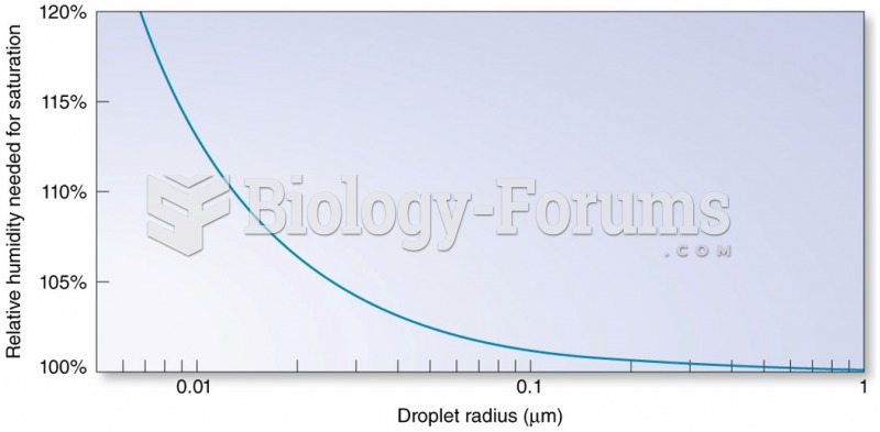 Factors Affecting Saturation and Condensation: Effect of Solution